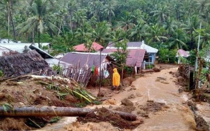
CATASTROPHE. Mudflow is seen in a village in Baybay City, Leyte in this April 11, 2022 photo after the onslaught of Tropical Depression Agaton. The Mines and Geosciences Bureau will update the geohazard map of areas in Leyte highly susceptible to landslides. (Photo courtesy of Rep. Carl Cari)
TACLOBAN CITY – The Mines and Geosciences Bureau (MGB) will come up with updated geohazard maps for areas highly vulnerable to landslides in Leyte, an official said on Tuesday.
MGB Eastern Visayas Regional Director Carlos Tayag said in a phone interview that he asked MGB geologists to update maps, especially in areas where there are requests from local government units.
“We cannot make updated maps in all areas. We will just carry it out through our regular activities. The focus is the proposed relocation sites,” Tayag said in a phone interview.
The latest geohazard map completed in 2014 became available online in 2016. It is the output of the Department of Environment and Natural Resources-MGB National Geohazard Assessment Program.
The "Geohazard Web Portal" icon uses online base maps accessed from the Philippine Geoportal System of the National Mapping and Resource Information Authority, while the "Geohazard Map Visualization on Google" utilizes Google Street Map and Google Earth.
Printed copies of these maps were distributed to all local government units (LGUs) in 2016. In the past seven years, MGB has been explaining to the local communities how to use these maps.
“Through the use of these maps, communities at risk can better prepare for natural hazards and avoid disaster. We will see if these maps are being used as a reference for the preparation and updating of the Comprehensive Land Use Plans of our local government units,” Tayag added.
The MGB regional office initially identified eight villages in Baybay City as danger zones after showing early signs of landslides.
The MGB found the susceptibility of these communities after a thorough assessment of these areas in response to reports from residents of visible tension cracks.
These sites are in the villages of Mailhi, Kantagnos, Bunga, Maypatag, Makinhas, Cagumay, Mag-aso, and Kan-ipa.
The result of the assessment has been relayed to local government units for the enforcement of “no dwelling zones.”
On April 10, at least 128 people died due to several landslide incidents in Baybay City.
Two days later, a village in Abuyog, Leyte was wiped out by a landslide killing at least 58 residents. (PNA)
(Editor's note: Updated story from the earlier version that the latest geohazard map was completed in 2016. It was in 2014.)
